
For many people in Bihar, the monsoon does not arrive with rain alone. It arrives with uncertainty.
Will the river rise again? Will the road remain open? Will the crops survive? Will families have to leave their homes once more?
These are familiar questions for people living in Bihar’s flood-prone regions. Year after year, rivers overflow, fields go underwater, roads and villages are cut off, homes are damaged, livelihoods are disrupted, and families are forced to rebuild what they can after the water recedes.
But if Bihar has faced floods for generations, an important question remains:
Why does this keep happening?
It is easy to blame heavy rain. But Bihar’s flood story is much bigger than rainfall alone. Himalayan rivers carry huge amounts of water and sediment into a remarkably flat plain. River channels shift. Embankments and drainage systems influence how water moves. Villages, farms, roads, and other infrastructure have grown across the floodplain. Millions of people depend on this landscape for their homes and livelihoods.
The Kosi, Gandak, Bagmati, Kamla-Balan, and other rivers are not the sources of destruction alone. They are part of the geography that has shaped Bihar for centuries. The real challenge is learning how people, rivers, and development can exist together with less loss and suffering.
So why does Bihar face serious floods repeatedly? Why are some places more vulnerable than others? What does the story of the Kosi teach us? And can Bihar reduce the human cost of floods without pretending that its rivers can be stopped?
This is the deeper story behind Bihar’s recurring floods: water, geography, human vulnerability, and development shaping the same landscape, year after year.
Why Is Bihar So Vulnerable to Floods?
If floods are a natural part of a river’s life, why do they become such a devastating problem in Bihar?
A major part of the answer begins with Bihar’s geography.
To the north are the Himalayas and the foothills of Nepal. Rivers such as the Kosi, Gandak, Bagmati, Kamla-Balan and Mahananda descend from this higher terrain into the plains of Bihar, carrying large volumes of water and heavy sediment loads. Much of their catchment lies outside of the Bihar, meaning that rainfall and runoff upstream can have consequences for communities downstream. Bihar’s own flood-management system identifies the region from the Burhi Gandak in the west to the Kosi in the east as its most flood-prone area.
The landscape makes the situation more difficult.
As these rivers move from the Himalayas into the much flatter alluvial plains, their flow conditions change. Sediment is deposited, banks erode, channels migrate, and water can spread across the floodplain. North Bihar has a long history of flooding, erosion, and changing river courses. The Kosi is a particularly clear example of how a river can reshape the landscape over time.
So, is Bihar vulnerable because nature made it vulnerable?
Yes, partly. But that cannot be the whole answer.
A river does not decide where a village will grow, where farmland will be cultivated, where a road will cross a floodplain, or how close a family will live to an embankment. People make those choices, but they do so within limits created by land, livelihood, poverty, history, and the options available to them.
And that raises a difficult question: when people have lived in these places for generations, where are they supposed to go?
For a farming family, leaving flood-prone land is not an easy decision when that same land provides food and income. Livestock may represent years of savings. A road may be the only connection to a market, school or health center. When floodwater cuts these connections, the loss is not limited to the waterlogged days. A damaged crop can mean debt. A damaged road can mean isolation. A disrupted school can mean lost learning.
This is why the same flood does not affect every household in the same way. Being exposed to floodwater is only one part of vulnerability. The condition of a home, dependence on agriculture, financial security, access to healthcare and education, warning systems, transport and the ability to recover all shape what happens after the water arrives. Research on Bihar has found substantial differences in flood vulnerability between districts because exposure, sensitivity and the capacity to adapt are not the same everywhere.
Then comes the question of protection.
Embankments, drainage systems, roads, forecasting and other measures are meant to reduce flood risk, and Bihar has built extensive embankment networks along its rivers. But such interventions also alter how water and sediment interact with the floodplain. Their effectiveness depends on location, design, maintenance, river behavior and what happens when water exceeds or breaches the system. Research from the Kosi region shows that the relationship between embankments and flood vulnerability is complex, with different consequences for communities depending on where they live and their social and economic circumstances.
This leads to a larger question that Bihar cannot avoid:
If floods are known to return, why should people have to face the same level of loss every time?
The answer cannot be to blame rainfall alone. Nor can it be assumed that every flood can be prevented by building another structure. Long-term flood management also involves land-use planning, maintenance, drainage, early warnings, evacuation, resilient infrastructure, livelihood security and the ability of communities to recover.
Hence, Bihar’s flood problem is not created at the right moment the water arrives. Risk builds where a dynamic river system meets a densely inhabited floodplain, vulnerable livelihoods, infrastructure and human decisions.
The rivers matter. So do the conditions in which people are expected to live alongside them.
And when the water finally reaches those homes, fields and roads, the flood is no longer only a geographical event. It becomes a question of food, work, health, education, displacement and survival.
When the Flood Is Not Just Water
A flood does not begin when water enters a house.
For the people living in Bihar’s flood-prone areas, the disruption can begin much earlier.
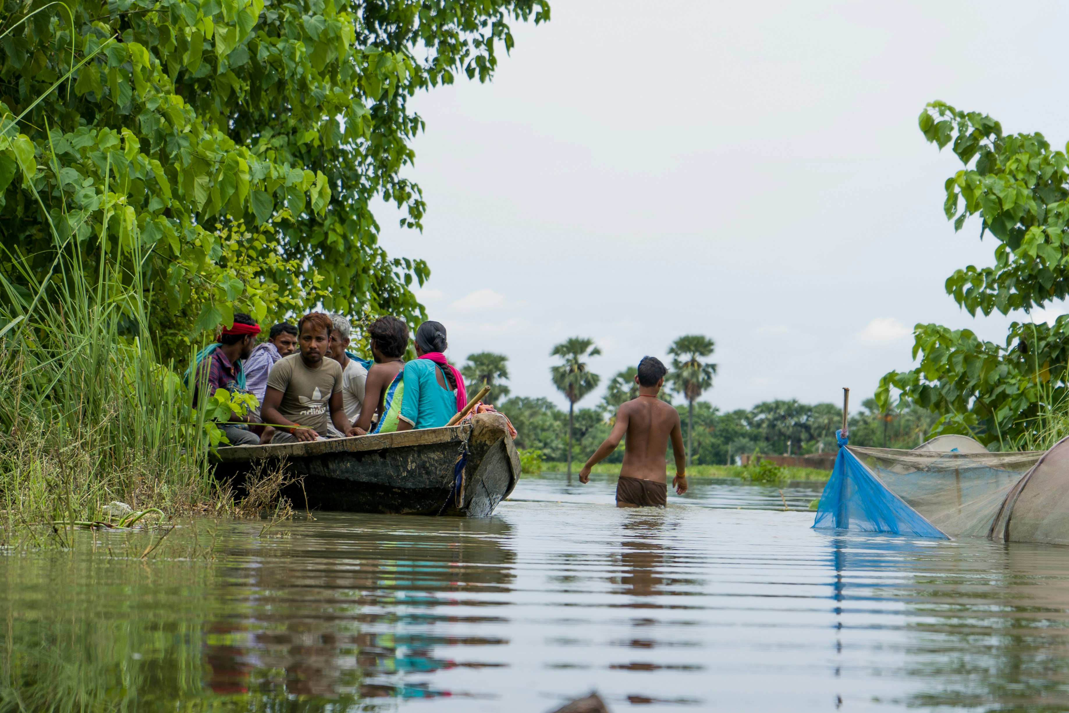
The river starts rising. A road that was usable yesterday becomes difficult to cross. People begin moving grains, clothes, documents, and other belongings to higher places. Farmers look at fields that were supposed to provide the next harvest. Families think about where the livestock can be taken. A phone call is made to a relative in a safer village.
No single moment explains the crisis. It builds as the water takes away one ordinary part of life after another.
And that is what makes a flood so difficult to understand from a distance.
From far away, it can look like a large area covered with water.
For the family living there, it can mean that the road to the market has disappeared, the school is closed, the field is underwater, the animals need somewhere to go, and the house may no longer be safe.
A flooded field is not just land under water.
It may be a crop that a farmer spent months cultivating. It may be money that has already been invested in seeds, labor, and fertilizer. It may have been the expected income to pay a debt, repair a house, buy food, or keep a child in school.
A study of 700 flood-affected households across Bihar found that damaged houses and crop loss were among the major risks households faced. It also documented livestock and livelihood losses, along with borrowing and financial transfers used to cope with the aftermath.
The water may cover the field for days. The financial consequences can last for months.
The same is true for work.
A daily-wage worker does not need to lose a house to lose an income. If the road is submerged, the workplace becomes unreachable. If transport stops, the day’s wage may disappear. If the local economy slows down, there may be fewer jobs to return to when the water recedes.
For a small farmer, the problem can be even more complicated. Agriculture, livestock, and household savings may all be tied to the same place. When a flood damages several of them at once, there is little left to fall back on.
This is why the phrase “flood-affected people” can hide more than it explains.
Two families may stand in the same water and experience completely different floods.
One may have savings, a strong house, another source of income, and relatives nearby. Another may have a fragile home, little savings, one crop as its main source of income, and no secure place to go. The water level may be the same. The consequences are not.
The difference is not only about how much water reaches a household. It is also about what that household has to fall back on. A 2026 study of rural Bihar found that greater flood height was associated with greater vulnerability to poverty, while education and asset ownership were associated with lower vulnerability.
That difference becomes especially important when floods return before families have fully recovered from the previous shock.
A damaged house has to be repaired.
A lost crop has to be replaced.
Livestock may have to be purchased again.
Debt still has to be repaid.
Children have to return to school.
And the next agricultural season does not wait for a family to become financially secure again.
This is one of the less visible costs of recurring floods: they can narrow a family’s choices.
A young person may leave the village for work because agriculture has become too uncertain. A family may borrow instead of investing. A farmer may reduce spending on the next crop because there is no guarantee that the harvest will survive. Migration may become part of the household’s survival strategy rather than a temporary search for better opportunities.
A 2026 study of flood-prone farm households in Seemanchal found that short-term internal migration was an important livelihood strategy, with remittances contributing to household income and risk management.
There is also a human cost that is harder to count.
Uncertainty.
What does it do to a family to know that the place they call home may become inaccessible during the monsoon?
What does it mean to build a house while knowing that another flood may damage it?
What happens when a child repeatedly loses days of school because the village cannot remain connected?
These losses rarely appear in a single flood-damage figure, but they shape people’s decisions over time.
And this is where calling a flood a “natural disaster” can hide an important part of the story.
The river’s rise is a natural process. The hardship that follows is shaped by much more.
It depends on where people live, what they own, what they depend on, how well their homes and roads withstand flooding, whether warnings reach them in time, whether they have somewhere safe to move, and how much support they have when the water goes down.
A flood is therefore not only a question of how much water arrived.
It is also a question of what that water meets.
In Bihar, it meets farms, villages, roads, schools, livestock, markets, homes, and livelihoods. It meets families whose ability to recover is not equal.
As a result, reducing flood damage cannot mean measuring success only by how much water was kept away.
It must also mean asking a harder question:
How much does a family lose when the water comes, and how quickly can it rebuild when the water leaves?
Because the real story of Bihar’s floods does not end when the river falls.
The mud remains.
The damaged house remains.
The lost income remains.
The debt may remain.
And sometimes, the decision to leave remains.
The water recedes. Life has to begin again.
Why Does Bihar’s Flood Problem Keep Returning?
If Bihar has lived with floods for generations, why does the same problem keep returning?
The answer is not found in one river, one embankment, or one season of heavy rain. Bihar’s recurring flood problem has been shaped by the way rivers behave, people live, land is used, infrastructure is built, and communities prepare for what they know may come.
The difficulty is that none of these things exists separately.
A river changes its course. A village has to remain where people can farm and earn. Roads have to cross the same landscape. Embankments are built to protect settlements and farmland. Drainage has to carry water away. Families need warning before evacuation becomes necessary. And when a flood damages homes or livelihoods, people need enough security to recover before the next shock arrives.
The problem keeps returning because the underlying conditions keep interacting.
The Rivers Keep Changing, But Life Has to Stay
One of the hardest realities of Bihar’s flood landscape is that rivers are not fixed lines on a map.
Rivers carry water and sediment from their catchments into the plains. As their flow changes, sediment can be deposited, riverbanks can erode, and channels can shift. In a flat alluvial landscape, even relatively small changes in the course or movement of a river can matter to the people living nearby.
This is particularly important in North Bihar, where several major rivers descend from the Himalayan region and Nepal into the plains.
A river may change.
A field cannot move with it.
A road cannot be rebuilt somewhere else every monsoon.
A village cannot relocate every time the river changes its course.
That difference between a moving river and a settled human landscape is at the heart of Bihar’s difficulty.
People have built their lives around the land available to them. Houses have been constructed. Fields have been cultivated for generations. Roads, schools, markets and other facilities have developed around existing settlements. These decisions are not made in an empty landscape. They are shaped by land availability, livelihoods, family history and economic circumstances.
This is why river behavior cannot be understood separately from human settlement.
The floodplain is not unused land waiting for the next flood. It is a lived landscape.
And that creates a difficult balance. People need protection from destructive flooding, but protection itself has to work within a river system that continues to carry water and sediment and respond to changing conditions.
People Cannot Just Move Away from the Water
From a distance, the solution to living in a flood-prone area can sound easy: move people
somewhere safer.
For many families, it is not.
The same land that carries flood risk may also provide farmland, employment, livestock grazing, family homes and access to local markets. Moving away may mean giving up the economic base that allows a household to survive.
For a small farmer, the question is not only “Is this land safe?”
It is also:
“If I leave this land, how will I live?”
That is why flood management cannot be reduced to tell people where they should or should not live. It has to consider the realities that keep people connected to vulnerable places.
This is also where infrastructure becomes important.
Embankments have been built across Bihar to protect settlements and agricultural land from flooding. They can provide important protection, but they do not make the river disappear. Their effectiveness depends on factors such as design, location, maintenance,
river behavior and the amount of water and sediment involved.
The relationship between embankments and flooding is therefore more complicated than saying that they are either the solution or the problem.
A structure may protect one area while changing how water behaves elsewhere. A well-maintained system may perform differently from a neglected one. A river may behave differently under conditions that exceed what infrastructure was designed to handle.
The same is true of roads and other developments.
A road can connect a village to a market, school or hospital. But if drainage is inadequate, the same road can also affect how water moves across the surrounding landscape. A bridge can improve connectivity, but its design and maintenance matter when rivers rise.
This does not mean development itself is the problem.
It means development has to understand the landscape on which it is built.
Bihar does not have the option of choosing between people and rivers. Millions of people
already live within this river system.
The real question is how settlements, agriculture, infrastructure and river behavior can be managed together so that the presence of a river does not automatically translate into repeated human loss.
Knowing the Flood Is Coming Changes What Happens Next
Bihar cannot prevent every river from rising.
But there is a major difference between being unable to stop a flood and being unable to prepare for it.
If people receive a warning early enough, they can move children and older family members to safer places. Livestock can be moved. Grains, documents, medicines and other essential belongings can be protected. Schools and local authorities can prepare evacuation spaces. Roads and emergency services can be organized before conditions become dangerous.
The difference may be measured in hours, but for a family facing rising water, those hours can matter enormously.
This is why flood management is not only about large engineering projects.
It also depends on forecasting, early warnings, evacuation plans, drainage, road connectivity, maintenance, emergency communication and community preparedness.
A warning that never reaches the people who need it is not enough.
A road that becomes unusable during an emergency creates another problem.
A drainage system that cannot cope with the surrounding conditions can leave water trapped after the main river has fallen.
A relief system that arrives late can make recovery harder for families who have already lost their income.
The quality of preparation therefore shapes what happens when the river rises.
This is also where Bihar’s flood challenge becomes a question of long-term planning rather than seasonal response.
Every monsoon brings attention to the immediate crisis: where the water is rising, which roads are closed, where people need to be evacuated and where relief is required.
Those responses are necessary.
But recurring floods also demand attention during the months when there is no emergency. Infrastructure needs maintenance. Vulnerable settlements need better planning. Drainage needs to function before the next monsoon. Warning systems need to reach people in usable form. Schools, health facilities and roads in flood-prone areas need greater resilience.
And households need stronger economic security so that one flood does not push them deeper into debt or force them to abandon their livelihoods.
Climate change adds another layer of uncertainty. Changes in rainfall patterns and extreme rainfall can influence flood risk, but they do not explain Bihar’s recurring floods by themselves. Geography, rivers, sediment, settlement patterns and existing vulnerability remain central to the story. This is part of a wider question about why some natural disasters are becoming more frequent or intense.
That distinction matters.
If every flood is explained only through extreme rainfall or climate change, some of the conditions that can be addressed through better planning and preparedness disappear from view.
Likewise, if every flood is treated as a purely natural event, the human decisions that shape exposure and recovery are overlooked.
The goal cannot be to create a Bihar in which rivers never overflow.
The more realistic goal is to create a Bihar in which a rising river does not automatically become a human catastrophe.
That means understanding where risk is highest, protecting people without pretending that structures can control every river behavior, improving warnings and evacuation, maintaining infrastructure, strengthening livelihoods and making development decisions with the floodplain in mind.
Because Bihar’s flood problem is not renewed from zero every year.
The river brings new water and changing conditions, but the vulnerability built into homes, livelihoods, infrastructure and institutions can remain.
That is why the question is bigger than “How do we stop the next flood?”
It is:
“How do we make the next flood less destructive than the last one?”
And nowhere is this tension between a powerful river and a settled human landscape clearer than in the story of the Kosi.
The Kosi and the Story of a River That Keeps Moving
Among Bihar’s rivers, the Kosi has become deeply associated with floods. But calling it a destructive river tells only one part of its story.
The Kosi is a Himalayan River carrying enormous amounts of water and sediment into the plains. As it leaves the mountains and enters the much flatter landscape of North Bihar, the river’s character changes. Sediment is deposited, channels can divide and reconnect, banks erode, and the river can shift across its broad alluvial fan.
That creates a difficult relationship between the river and the people living around it.
People need stable homes, fields, roads, and settlements.
The river does not always offer stable ground beneath them.
A River Does Not Follow the Map Forever
The Kosi’s changing course is not a recent phenomenon.
Its large alluvial fan contains traces of older channels, showing how the river has shifted across the landscape over time. Research has also challenged the familiar claim that the Kosi simply moved more than 100 kilometers westward in one continuous direction over the last two centuries. Historical maps and geomorphological evidence suggest a more complicated pattern of channel switching and avulsion.
That distinction matters.
A river that shifts between different parts of a floodplain creates a very different kind of risk from a river whose course remains relatively fixed.
The Kosi’s behavior is influenced by its sediment load, channel form, slope and the shape of the megafan. During major changes in the river’s course, water can move into areas that have not experienced the same level of flooding for many years.
The events of August 2008 showed just how serious that possibility can be.
On 18 August, the eastern Kosi afflux embankment near Kusaha in Nepal was breached. The river rapidly shifted into another course, producing catastrophic flooding across large parts of northern Bihar. The event affected areas including Supaul, Madhepura, Araria, Saharsa, Katihar and Purnia. Bihar’s flood-management records describe the river as having entirely changed its course during the event.
What made 2008 so significant was not merely that water crossed an embankment.
The river changed the landscape through which it was flowing.
Research on the event describes it as a major avulsion, with the river moving into an older channel system. Areas that had not experienced comparable flooding for decades were suddenly exposed.
For the people living there, the difference between an ordinary monsoon flood and a sudden change in the river’s course was enormous.
The map had changed.
So had the meaning of the land.
The Embankment Was Not the Whole Story
The 2008 disaster also shows why the Kosi cannot be discussed only as a “natural” flood.
Embankments had been built to protect settlements and agricultural land from the river. They remain an important part of Bihar’s flood-management system. But an embankment is a protective structure, not a permanent command over a river.
The Kosi continues to carry sediment. Its channels continue to evolve. The condition of an embankment, its maintenance, the river’s pressure on it, and the wider drainage system all matter.
Research on the Kosi has found that the relationship between embankments and flood vulnerability is complex. Human interventions can influence the river’s behavior and the distribution of flood risk, while the consequences differ across locations.
So, it would be misleading to say that embankments are simply the cause of Bihar’s flood problem.
It would be equally misleading to treat them as a final answer.
The lesson is more uncomfortable than either conclusion.
Protection has limits.
The 2008 breach demonstrated how a failure at one point in a river system can affect communities far beyond that location. It also showed why flood management cannot depend on one structure alone.
Forecasting, monitoring, maintenance, early warning, evacuation planning and cooperation across the river basin all become important when dealing with a river whose behavior can change suddenly.
The Kosi therefore teaches Bihar something larger than the story of one disastrous flood.
A river does not have to be defeated for people to live more safely beside it.
It has to be understood.
Its sediment has to be understood. Its channels have to be monitored. Its vulnerable stretches have to be identified. Protective structures have to be maintained. Communities need enough warning to act before rising water turns into an emergency.
And even then, uncertainty remains.
That may be the most important lesson of the Kosi.
The goal is not to make a changing river behave like a fixed line on a map. It is to make human life less vulnerable to the changes that the river will inevitably bring.
The Kosi’s story therefore leads naturally to the question Bihar now has to confront: if its rivers cannot be stopped, how can their human cost be reduced?
Can Bihar Ever Stop Floods Completely?
Completely stopping floods in Bihar is neither realistic nor necessary.
Much of northern Bihar is a flat alluvial plain, receiving rivers that descend from the Himalayas and carry large amounts of water and sediment into the region. Flooding is therefore deeply connected to the landscape itself.
The more realistic question is:
Can Bihar reduce the damage floods cause, protect people better, and help communities recover faster when flooding occurs?
That requires a different way of thinking about flood management.
The Goal Should Not Be a Flood-Free Bihar
A flood is a natural process. A disaster is shaped by what happens when that water meets homes, farms, roads, livelihoods, and vulnerable communities.
Bihar cannot control every monsoon, upstream rainfall event, or river movement. But it can influence how much human suffering follows.
Success should therefore not be measured only by how much water is kept away. It should also be measured by how many lives are protected, how much disruption is prevented, and how quickly affected communities can recover.
The aim is not to remove rivers from Bihar’s landscape.
It is to make life safer alongside them.
Know the River Before Trying to Control It
Good flood management begins with understanding how rivers behave.
River channels change. Sediment moves. Banks erode. Drainage patterns evolve. Water does not always follow the same path with the same intensity.
The Kosi makes this especially clear, but the broader lesson applies across Bihar’s river systems.
This requires continuous monitoring of river levels, rainfall, erosion, sediment, drainage, and areas repeatedly exposed to flooding. Such information can guide decisions about where infrastructure needs strengthening, where drainage requires attention and which communities face the greatest risk.
A river cannot be managed well if it is treated as a fixed line on a map.
A Warning Is Useful Only If People Can Act
Forecasting has little value if a warning reaches people too late.
For a family living near a river, a useful warning is one that gives enough time to move to safety, protect essential belongings, arrange transport, move livestock and reach a secure shelter.
That requires more than technology. Information has to travel from monitoring systems to local authorities and, ultimately, to the people who need to act.
Early warning is not only about predicting the flood. It is about creating time to respond to it.
That difference can determine whether rising water becomes a manageable emergency or a sudden crisis.
Flood Management Is Also a Test of Governance
There is another part of flood management that cannot be solved by rivers, technology, or engineering alone.
Governance.
Bihar knows that floods will return. The vulnerable districts are not unknown. The major rivers are not new. The need for embankment maintenance, drainage, evacuation plans, shelters, early warnings and relief systems is not a surprise that arrives with the first heavy rain.
That raises an uncomfortable question:
If a disaster is recurring, how much of the response should still be treated as an emergency?
The state has institutions specifically responsible for disaster preparedness and risk reduction. Bihar’s disaster-management framework calls for risk-informed planning, resilient infrastructure, and disaster preparedness to be integrated into governance and development. In June 2026, the Bihar State Disaster Management Authority reviewed flood preparedness across 15 flood-prone districts, including embankment safety, evacuation plans and flood shelters. The review also identified the need for cleaning, maintenance, and improvement of some permanent flood shelters.
This is where accountability matters.
A government cannot prevent every flood. It can, however, prepare before the water rises.
That means maintaining embankments before the monsoon, keeping drainage systems functional, identifying evacuation routes, ensuring shelters are usable, preparing rescue equipment, strengthening local response teams and making sure warnings reach people in time.
And the responsibility does not belong only to government departments.
It also belongs to public representatives.
When floods arrive, elected representatives may visit affected areas, meet families, inspect relief work or help mobilise support. Such visits can be valuable when they lead to practical assistance. But the deeper responsibility begins before the cameras arrive and continues after they leave.
People living in flood-prone areas need representation when there is no flood too.
They need roads repaired before the next monsoon. They need questions raised about drainage and embankment maintenance. They need schools, health centres and shelters that remain functional during disruption. They need their repeated losses to become part of long-term planning rather than being treated as a fresh crisis every year.
This leads to a basic principle of public service:
Relief responds to suffering. Good governance works to reduce how much suffering occurs in the first place.
Civil society also has an important role. Volunteers, community groups, educators, public figures and ordinary citizens who step forward during floods can provide food, medicine, transport, financial support or attention to people who might otherwise remain unseen.
Those efforts matter.
But they should strengthen public systems, not become a substitute for them.
Human kindness can save a family today. Effective institutions can protect thousands tomorrow.
That is why Bihar’s flood challenge is also a test of institutional memory, accountability, and public responsibility.
The question is not whether every politician can personally rescue someone from floodwater.
The question is whether the system learns from one flood before the next one arrives.
Build With the Floodplain, Not Against It
Bihar will continue to need roads, bridges, schools, health centers, homes and markets. The answer is not to stop development in flood-prone areas altogether.
The harder question is how and where development should take place.
Infrastructure in exposed areas needs to account for the possibility of flooding. Roads and bridges need reliable access during emergencies. Critical facilities may need to be designed or located with flood risk in mind. Houses, drinking-water systems and public buildings also need greater resilience where exposure is high.
Protective structures such as embankments have an important role, but they cannot be treated as permanent guarantees of safety. Their condition, maintenance, drainage and the behaviour of the river around them all matter.
Flood management is therefore also a question of development planning.
Recovery Is Part of Flood Management
There is one final question that deserves more attention:
What happens after the water recedes?
A family may survive the flood and still face months of difficulty. Roads have to reopen. Schools have to function again. Crops and livestock may need replacing. Houses may need repair. Local markets and livelihoods have to recover.
For farming households, recovery may also mean access to seeds, credit, insurance, or alternative sources of income so that one damaged season does not become a much longer cycle of debt.
This is why disaster management cannot end with evacuation and relief.
The real measure of resilience is not only how well people survive the flood, but how quickly they can rebuild their lives afterward.
Bihar may never become a place where floods disappear completely. Its rivers, plains, and monsoon environment make that expectation unrealistic.
But a flood does not have to produce the same level of suffering every time.
The river may remain part of Bihar’s landscape. The scale of human loss can change.
Bihar Does Not Need to Defeat Its Rivers
Bihar’s rivers are not an enemy that can be defeated. They are part of the landscape that has shaped the state for centuries.
The Kosi, Gandak, Bagmati and other rivers will continue to respond to rainfall, sediment, slope and the shape of the land. The question is not whether Bihar can make them behave like fixed lines on a map.
The real question is whether people can live with these rivers in ways that make them less vulnerable to what the rivers naturally do.
That means development has to respect the landscape. Homes, roads, bridges, schools and other infrastructure in flood-prone areas need to be planned according to the risks of the places where they are built. Where possible, people and essential infrastructure should be kept away from the most dangerous areas. Where living with the river is unavoidable, resilience has to become part of how communities build, work and prepare.
The aim is not to eliminate every flood.
It is to prevent a flood from becoming a disaster that lasts long after the water has gone.
A resilient Bihar would not measure progress only by how much water it can keep away. It would also ask how many people can remain safe, how quickly roads and schools can reopen, how much livelihood can be protected, and whether a family can recover without being pushed deeper into debt or forced to start its life again.
For this requires responsibility at every level. Governments have to plan before the monsoon, institutions have to learn from previous floods, public representatives have to remain accountable beyond moments of crisis, and communities need the knowledge and resources to prepare themselves.
But resilience also means accepting a basic truth about the landscape.
People cannot always change the river. They can change how they live beside it.
Bihar does not need to defeat its rivers.
It needs to understand them, respect the landscape they have created, and build a future in which their presence does not automatically mean human suffering.
The river will continue to flow.
What changes is how vulnerable people are when it does.